Visitors

Friday, December 23, 2011

My New Neighbor

by Pa Rock
Street entrance of Drugstore Mori
Cultural Explorer


One  thing that I am learning about Okinawa is that when it comes to real estate, things happen quickly.  No sooner is one building knocked down than another springs up to take its place - often in just a matter of weeks.

Drugstore Mori of Chatan
That phenomenon recently occurred right here in my hood.  My apartment house had been positioned between two pachinko parlors, each about a block from my front and back doors.  And though Okinawans and Americans seem to love the noisy and smokey gambling centers, two that close together were a bit much.  So I wasn't surprised when construction tape appeared around one of them, and the building was knocked down and the site leveled in just a couple of days.

I was surprised, however, when I happened to notice a few weeks later that a modern drugstore, Drugstore Mori, is now sitting on the same location - open and ready for business.

I ventured through the new business last week and discovered lots of Japanese products typical of what might be found in a Walgreen's in the United States, as well as many American brands.  My purchase:  four plastic bottles of milk tea which was selling for about twenty cents a bottle less than I would have  paid on base!

Milk tea is one of the things I will miss about living in Japan.

Sunday, December 11, 2011

Okinawa by Air

A thorn among the roses!
by Pa Rock
Cultural Explorer


Two weeks ago my friend Valerie and I took another air tour of Okinawa with Bryan the pilot.  This time we covered the northern end of the island.   We flew from Kadena to the East China Sea - a matter of minutes - to the island of Ie Shima, northward along the coast to Cape Hedo, the northernmost point of Okinawa, down the Pacific Coast to just north of Naha, across the island,and back to Kadena - essentially seeing those parts of the island that we were not exposed to on our first flight.
Fasten those seat belts.  It's going to be a bumpy ride!
Who knew the pilot would bail?

Agricultural area of Ie Shima
We were accompanied on this trip by Valerie's Okinawan friend, Atsuko.  This was actually a birthday flight for Atsuko.  She lives in Nago and teaches on the nearby island of Ie Shima.  (Ie Shima is the island where journalist Ernie Pyle was killed by a Japanese sniper during World War II.)   As part of this tour we flew over Ie Shima and were able to see the school where Atsuko teaches.

Sit back and enjoy the tour!


Urban area of Ie Shima.  Schools are near the sports
track at center of photo.
Cape Hedo
Part of the Pacific Coast
Araha Beach, Okinawa - my 'hood'
Coming in for a landing.
Atsuko and Valerie watching Bryan refuel the plane.

Scenes Along the Road South of Naha

Naha Chapel - now on Japanese governemnt land.
I was married in that chapel in 1972
by Pa Rock
Cultural Explorer


Here are a few scenes shot from the car window as we headed south of Naha toward Itoman and Peace Park two weeks ago.  Just some odds and ends to give a clearer view of this small island.


Buildings along the southern edge of Naha
Maui - a restaurant in Itoman
Construction at a commercial building 
Closed storefront adorned with a rocket.
Apartment building in the background.
A pineapple establishment.  Pineapple is a very
popular, locally-grown product.
Street corner in Itoman
Attractive commercial building

Saturday, December 10, 2011

Peace Park - Second Visit

A view of the Pacific from Peace Park
Kelly and Valerie with bouquets to decorate memorials
by Pa Rock
A memorial at Peace Park
Cultural Explorer


Two weeks ago today I went to Peace Park on the southern tip of Okinawa with two good friends.  We did a much more thorough exploration of the immense park this time than I was able to accomplish last year when I first visited the site.

Well, I actually visited Peace Park first nearly forty years ago.  At that time, it was much smaller, just a couple of acres of memorials on the cliffs jutting out over the Pacific Ocean.  We referred to the place as "Suicide Cliffs" back at that time.  It is the spot where many Japanese servicemen marched off of the cliffs to certain death on the rocks below rather than risk capture by the American forces.

Today Peace Park is much larger - probably more than a hundred acres.  There are memorials everywhere, as well as a very large learning center that has displays, films, and records from the war.  This park is dedicated to preserving the history of Okinawa during World War II as well as reminding people that "peace" is the better option.  And yes, war and peace are ultimately options.

Yet another memorial
One of the most interesting memorials in the park is a wide expanse of granite walls that have the names of all of the servicemen, Japanese and Americans, who died fighting on Okinawa.  We met a very nice couple from Indiana who were walking along the American walls looking for Ernie Pyle's name.  (Pyle was a nationally known newspaper correspondent from Indiana who was killed by a sniper during the battle for Okinawa.)  They ultimately found two Pyle's with different first names.

Here are just a very few photos from this beautiful park.
Chains of origami paper cranes decorated some of
the memorials
Bill and Jen McDonald - American school teachers
serving in Japan - along with Valerie and Kelly.
A panel in the American memorial wall
A view of the top of the learning center as seen from
an observation post
A diorama inside the learning center
Another memorial.  The gardens were beautiful!


Friday, December 9, 2011

Itoman Glass Factory and Pottery

Tommy Lee Jones - a fixture on many Okinawan
soft drink machines.
Clay sculptors making Shisa Dogs
by  Pa Rock
Cultural Explorer


Two weeks ago my friends Valerie and Kelly and I drove south to the glass factory and pottery at Itoman where we purchased a few holiday gifts and then traveled on further south to Peace Park, a memorial to servicemen, both Japanese and Americans, that is located on the southernmost tip of Okinawa.  I had made this same trip last year with another friend, Daniel, so some of the pictures may look familiar.

Okinawan lad running a booth at the glass factory -
when Okinawans pose, it is always with the
peace sign.

Forty years ago Itoman was little more than a fishing village.  I can remember driving through on our way to Peace Park, then called Suicide Cliffs, and seeing the fishermen hard at work along the shore mending their nets.   Today Itoman is a bustling city, actually an extension of the capital, Naha, with buildings so dense that there is no view of the sea from the main road.

It was a nice Saturday outing.
A glassblower at work

Fine glassware from Itoman

Glass sculpture of a tangle of snakes

Assorted Itoman glassware

Sunday, December 4, 2011

Guam: The Hilton Hotel

Front entryway to the Hilton.  Holiday decorations were
going up while we were there!
by Pa Rock
Globe Trotter


Can't depart the pictorial tour of Guam without including a couple of photos of the Hilton Hotel, our headquarters for the four days that we were on the island.  The Hilton is located on Tumon Bay along with all of the other big-name hotels.  It is a beautiful stretch of beach edging along some of the bluest water in the world.
The hotel's flags were at half-staff out of
respect to a local National Guardsman
who had been killed in Afghanistan
the preceding week.
An outdoor bar and grill behind the hotel.
Valerie said that concoction was non-alcoholic!
Adios, Guam!

Guam Day 4: The University of Guam

The University of Guam
by Pa Rock
Globe Trotter


This was our final day on the island of Guam.  We checked out of the hotel early and hit the road to take in a few more sights.  One of our primary destinations was the University of Guam which had been a junior college in the not too distant past.  The current university is still so small that a couple of the island residents whom we asked for directions did not even know that there was an institution of higher learning on Guam.

It was another beautiful day!

Valerie entering the Humanities and Social Sciences Building


Valerie and Social Work Professor Gerhard Schwab
Some student expression
The University Library
A view of the campus
Students enjoying lunch on the lawn outside of
the Student Center

Saturday, December 3, 2011

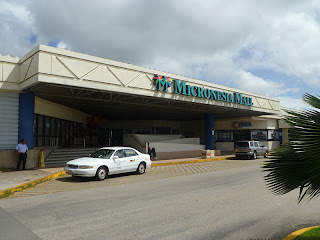
Guam Day 3: At the Micronesia Mall

Me and one of my new friends.
by Pa Rock
World Traveler


On the third day we went to Andersen Air Force Base where we shopped for souvenirs and tee-shirts, and other important stuff.  While at the Base, someone told Valerie about a good place to get a pedicure at the Micronesia Mall.

The Micronesia Mall:  Main Entrance
The anchor store at the Micronesia Mall is a large Macy's.  While Valerie had her feet fussed over, I hit the bookstore and then took in a movie - J. Edgar.


Day 3 was about relaxing.

Sunday, November 27, 2011

Guam Day 2: Talofofo Falls and Shoichi Yokoi's "Cave"

by Pa Rock
Talofofo Falls Park Office  (We found several immense
spiders on the stones fronting the structure.)
World Traveler


We did an about-face at Jeff's Pirate Cove and headed south.  It took about twenty minutes and lots of attention to road signs, but we finally located park that is home to both the beautiful Talofofo Falls and the supposed hidey-hole/cave where Japanese soldier Shoichi Yokoi hid for twenty-seven years between 1945 and 1972 because nobody bothered to tell him that the war was over,

Religious statuary in the main park.
The park was very secluded in an area that was overrun with much greenery.  We bought admission tickets, careful to get our military discounts, and then walked along some odd exhibits including a large cage holding two reindeer which were being fed.   I don't know the significance of the reindeer, but they are definitely not indigenous to Guam

We came to a building where we were asked to be seated in a large, clear plastic vessel that was hooked to a cable.  We rode the cable car down over a steep ravine that was thick with jungle growth, and passed the falls enroute to the bottom of the hill.

Reindeer at feeding time.
Preparing to descend  into the valley.
Once we were on the ground, we followed a trail that went beside and below a very large system of water cascading over huge, water-worn boulders.  Eventually we got to the other side where we found a gift shop that appeared to be closed, and a small museum.

A small trail ran beside the gift shop and out into the jungle.  We followed it for a quarter-of-a-mile or so until we finally reached a sign informing us that the cane-lined hole at the site was the place where Shoichi had hidden all those many years.  Reportedly the hole went down eight feet or so and then branched out into a horizontal hand-dug cavern.  The hole was not open for public inspection, nor did it look like the type of place into which proper tourists would want to descend.

Talofofo Falls
Valerie crossing a suspension bridge and taking a picture.
On our return to the spot where we were to board the cable car for our ride back up the mountain, a park guide told us that the thing was a fake.  He said that he had helped to dig the hole that we traipsed through the jungle to see.  The guide said that the actual cave was nearby on the top of a large hill, and that it was completely inaccessible to tourists.

Cascading water at the base of the hill.  Gift shop
and museum in background
The actual "cave:?
Back at the top of the mountain I asked another park guide about whether the hole that we had seen was actually where the brave soldier had spent all of those years in hiding.  She looked flustered and then said that it was not.  She said the original hole/cave had been destroyed during a typhoon, and they had dug a replacement on what they hoped was the exact site.  She denied that the actual cave was at a different location altogether.

One of several Buddhist shrines near the site.
We would have continued that discussion, but at that moment thirteen pigs of varying sizes strolled out of the jungle and commenced to lay about on the cool, shady parts of the parking lot.  We left the guide to play among the pigs!


Pigs at play!